


Samvel Meliksetian
(Continued. Beginning…)
Part 7
Highways, railways, and other transportation infrastructure
In addition to rail transport, a well-developed network of road transport was established during the Soviet era, many elements of which remain relevant to this day.
Highway routes served two key functions: first, they connected the Soviet republic with neighboring republics, largely replicating the main routes that had been established during the Russian Empire; second, they formed the internal transportation network of the Armenian SSR. In the latter case, especially from the mid-1950s onward, new domestic highways were actively constructed, including the Bagratashen–Alaverdi–Kirovakan, Yerevan–YYeraskh–Yeghegnadzor–Sisian–Goris, and Ijevan–Berd routes, among others.
The only highway of all-Union significance on the territory of Armenia was considered to be the M-24 highway (Yerevan–Sevan–Ijevan–Gazakh; classified as M-4 in Armenia since 1991), which connected to the main transport artery of Soviet Transcaucasia—the M-27 highway (Baku–Tbilisi–Sukhumi).
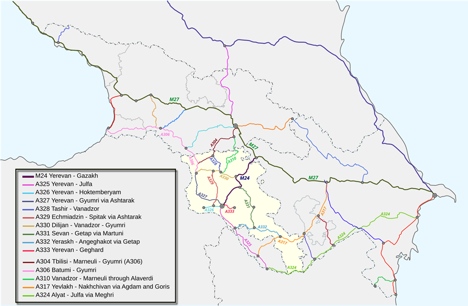
The system of major highways in Soviet Transcaucasia in the 1980s. The full-resolution map is available at the link – https://upload.wikimedia.org/wikipedia/commons/4/4c/Main_Roads_Armenia_1982-1996.svg
The second highway connecting Armenia with Azerbaijan—A-317 (Nakhichevan–Goris–Stepanakert–Yevlakh)—was in poorer technical condition and was therefore used much less frequently. At the same time, Nakhichevan maintained a stable road connection with Yerevan via Highway A-325.
In later Soviet atlases, particularly the 1986 edition, Route A-324 (Julfa–Alyat) was also marked, running through southern Armenia parallel to the railway line (the Meghri–Nrnadzor (Nyuvadi) section). However, this highway did not, in fact, function as a through route: while there was a road—difficult to maintain—from Meghri to the village of Nyuvadi, the Nyuvadi–Agbend section did not exist until the late 1980s. Thus, despite the data in Soviet road atlases and maps, a direct road connection between the Nakhichevan ASSR and the main territory of the Azerbaijan SSR via Meghri did not actually exist.
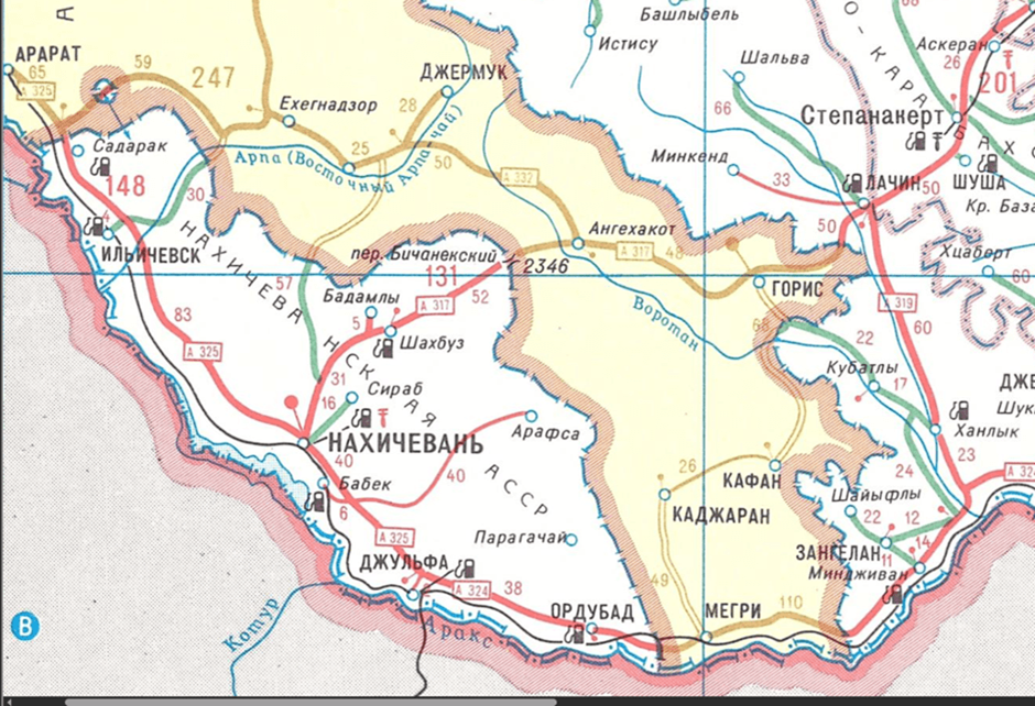
A map from the 1986 Soviet Road Atlas showing the supposedly operational A-324 highway (Julfa–Alyat), which in reality did not exist due to the impassability of the Shvanidzor–Agbend section.
The construction of this road remained the subject of intense inter-republican bargaining between Yerevan and Baku for many years. The version widely circulated in the contemporary Armenian press and expert community—that the leadership of Soviet Armenia deliberately blocked the project in an effort to thwart the “Pan-Turkist” plans of the Azerbaijani side—greatly oversimplifies the actual situation. This interpretation gained particular popularity following publications about the 2001 Key West agreements, which envisaged the creation of an extraterritorial corridor along the Araks River through the Meghri region of Armenia in exchange for Nagorno-Karabakh and a similar corridor for the Armenian side (the narrative regained popularity after November 2020). Within this logic, Soviet Armenian leaders were retrospectively portrayed as “patriots” who prevented a dangerous precedent, in contrast to Robert Kocharyan, who was depicted as a politician willing to make concessions regarding sovereign territory.
Meanwhile, in reality, the dispute over the road’s construction was not so much ideological as it was practical. The Armenian side did not simply object to the project but conditioned its consent on the fulfillment of a reciprocal demand—the construction of the Vardenis–Jermuk road through the territory of the Kelbajar District of the Azerbaijan SSR. Thus, in all likelihood, this was not a matter of a principled refusal, but rather an attempt to secure a symmetrical solution for the internal transport links of the Armenian SSR through Azerbaijani territory.
There is reason to believe that, had the USSR remained intact, both projects would presumably have been implemented. At the same time, during the Soviet period, Meghri, in addition to its railway connection, maintained a steady link with Yerevan via the convenient Meghri–Julfa–Nakhichevan–Yerevan highway, with a travel time of about three hours.
Overall, industrial development and the Soviet Union’s economic model—based on incomplete production cycles and, consequently, a high volume of interregional shipments—ensured record-breaking freight volumes during the Soviet era.
Table. Volume of road freight transport in the Armenian SSR, in millions of tons
| Year | 1965 | 1970 | 1975 | 1980 | 1985 | 1990 |
| Road freight transport, million tons | 113.1 | 264.1 | 300.3 | 307.2 | 300.3 | 251.5 |
In addition to railway and road infrastructure, the process of integrating the energy systems of the Soviet republics had been steadily developing in the USSR since the 1950s, largely completed by the 1970s. As part of this policy, construction began in 1957 on the Karadag (Absheron)–Kirovabad–Aghstafa–Tbilisi gas pipeline, with a branch line from Aghstafa to Yerevan. Until the Mozdok–Tbilisi–Yerevan gas pipeline was commissioned in 1988, this line remained the main route for gas supplies to Armenia.
From the early 1970s until 1980, the gas shortage at the Karadag field was offset by supplies from Iran via the Abadan–Astara line, which further underscores the cross-border nature of the region’s energy system. Within Armenia, the Karadagh–Aghstafa–Yerevan gas pipeline ran along the same transport corridor as the main M-24 highway (Kazakh–Ijevan–Dilijan) and the railway, forming a single infrastructure axis.
Map of the region’s gas infrastructure in the late Soviet era.
Gas and electricity supplies to the Nakhichevan Autonomous Soviet Socialist Republic were also routed through the territory of the Armenian SSR; this gas pipeline then continued on to the southern regions of Armenia itself. Thus, the cutoff of gas supplies to Sisian in late November 1991 led to a reciprocal suspension of gas deliveries to the Nakhichevan Autonomous Republic from Yerevan.
It is crucial to note, however, that the energy infrastructure of Armenia and the Nakhichevan ASSR was connected not in the southern section but in the northern section—in the YYeraskh and Sadarak area—which reflects the general logic of the Soviet infrastructure system, oriented toward inter-republican integration via key hubs.
Part 8
Communications During and After the Conflict
By the start of the Karabakh conflict in 1988, incidents had become frequent on all types of transport routes crossing the borders of the two Soviet republics. Although 1988–1989, largely due to the Spitak earthquake, saw record-breaking freight volumes on the railways of the South Caucasus (the Transcaucasian and Azerbaijani railways), the situation began to deteriorate rapidly as early as 1990.
The increase in the number of incidents on the tracks led to a significant reduction in inter-republican freight traffic. In January 1990, the YYeraskh–Sadarak railway section found itself in a zone of armed conflict. Although rail service on certain sections was subsequently temporarily restored, the situation remained extremely unstable. And in April 1992, train service between Nakhichevan and the main territory of Azerbaijan, as well as between Yerevan and the cities of Meghri and Kapan, was permanently suspended.
This was preceded by robberies of trains, attacks on trains, and physical violence against train drivers and service personnel, which had become widespread in the territories of both republics. Under these conditions, the operation of the railway network gradually ceased to be regular, although the heads of the relevant agencies in Baku and Yerevan tried to find solutions to the situation. Thus, on April 11, 1992, a meeting was held between the heads of the Armenian and Azerbaijani railways, Hambardzum Ghandilyan and Elbrus Abdullayev, during which the following issues were discussed:
1. Resumption of rail service between Ijevan and Aghstafa.
2. Measures to ensure the personal safety of locomotive crews at the Sharur and Ijevan stations and on the adjacent Ijevan–Barkhudarli and Yeraskh–Velidag–Sharur sections.
3. Systematic unloading and allocation of food, fuel, and other essential cargo bound for Armenia at stations on the Azerbaijani Railway.
4. Resumption of passenger service on the Yerevan–Meghri section.
5. Improving communication between the Armenian and Azerbaijani railways.
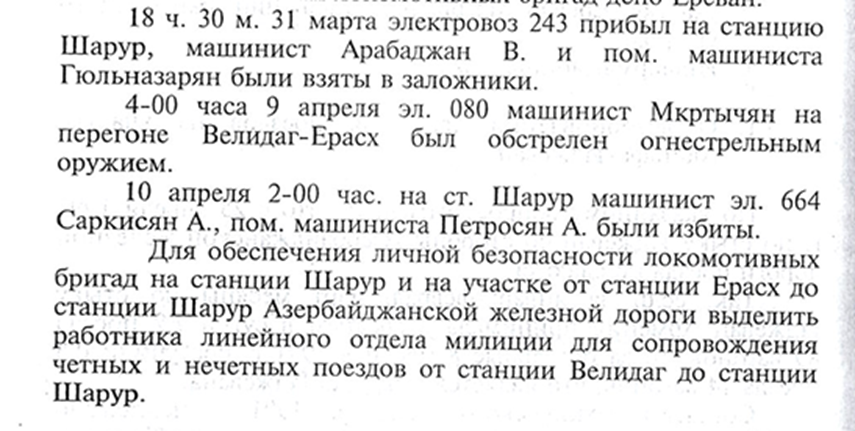
From the minutes of the meeting between the heads of the Armenian and Azerbaijani railways on April 11, 1992 (Collection of materials from the National Archives of Armenia, “Armenian Railway,” Yerevan, 2006)
Despite the noted accumulated problems and the expressed willingness to resolve them, no way to restore railway service between the countries was found. In August–November 1993, the Armenian side established control over approximately 145 km of railway along the Araks River—from the borders of the Meghri District to the section between the Bagmanly and Dashburun stations. However, by the spring of 1994, following fierce fighting, part of this section (about 30 km), including the Horadiz station, was returned to Azerbaijani control, and this station became the last functioning point of the line on Azerbaijani territory.
The Kapan–Mingivan branch line (39 km) also came entirely under Armenian control. In the following years, the railway tracks on these sections were dismantled. Specifically, in 2003, 32 of the 44.2 km of the Meghri–Nrnadzor (Nyuvadi) line were dismantled. The rails and other materials were sold to the Zangezur Mining and Metallurgical Complex for $320,000. Subsequently, the dismantling of the entire railway (44 km in the Meghri District) on this section was completed.
In 1992–1993, border clashes between Armenian and Azerbaijani armed forces also occurred along the Ijevan–Gazakh railway section. In April 1992, the Sofulu–Barkhudarlu enclave came under Armenian control; a 2.7-km section of the railway runs through this territory. In turn, Azerbaijani forces occupied a significant portion of Armenian territory (agricultural lands of the village of Vazashen) adjacent to the Aghstafa Reservoir from the south. Thus, the actual line of control in this zone changed significantly compared to the administrative border between the two republics.
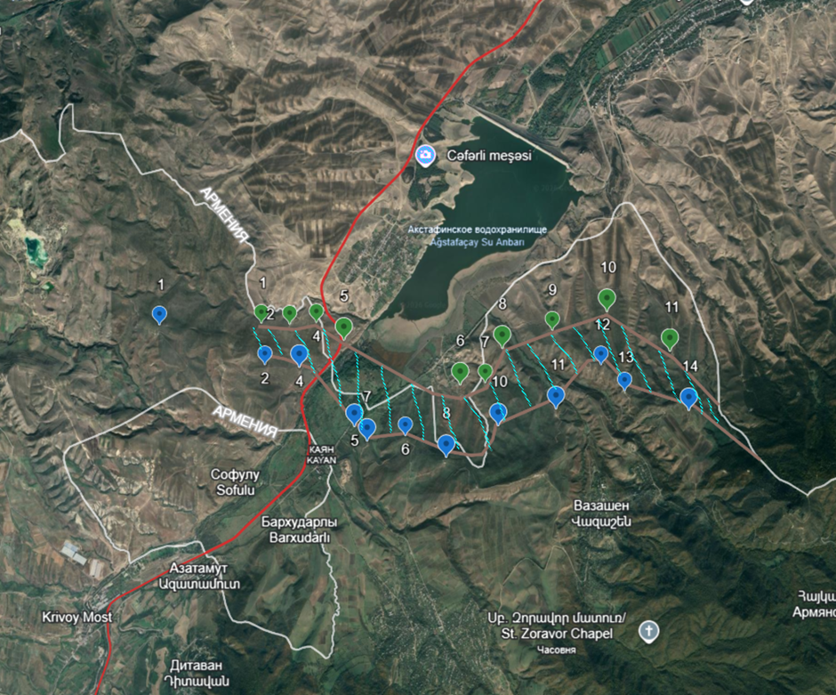
The border between Armenia and Azerbaijan (white line), the Ijevan–Gazakh railway (in red), and the strongholds of the Armenian (in blue) and Azerbaijani (in green) armies along the Gazakh–Ijevan section. The inter-position (neutral) zone is marked with hatching.
Traffic on the Ijevan–Dilijan section was suspended in 1994 due to a landslide that affected a stretch of approximately 1.7 km south of the village of Haghartsin. As a result, the Ijevan–Hrazdan line was divided into two isolated segments, and the Haghartsin–Ijevan–Barkhudarli section was removed from the country’s unified railway system. In a number of assessments within Armenian political discourse, the extent of the damage and the cost of restoring this section are presented as overstated. Meanwhile, while significant reinforcement and landslide-prevention measures are necessary, the restoration of this section is not among the most complex or costly tasks within the Hrazdan–Ijevan line.
The section up to Dilijan Station remained operational and was used for freight transport until 2012. Since the 1990s, the surviving portion of the Ijevan section has been partially looted, including the dismantling of the overhead contact system. However, rails, ties, engineering structures (bridges, overpasses), overhead contact line supports, and other infrastructure elements have been preserved along most of the line Dilijan–Ijevan—the border with Azerbaijan. Restoring rail service requires a complete overhaul of the track infrastructure (sleepers, rails, and some support poles), an inspection of the condition of engineering structures (including bridges and tunnels), and the modernization of the power infrastructure.
The military hostilities of the early 1990s, the severing of economic ties, the closure of the Armenian-Azerbaijani and Armenian-Turkish borders (since April 1993), as well as limited resources led to a sharp and massive decline in all types of transportation within Armenia. Thus, by 1998, the volume of freight transport had decreased by more than 70 times compared to 1990 levels.
| Year | Railways, million tons | Roads, million tons | Total volume, million tons | % of 1990 levels |
| 1990 | 15.7 | 251.5 | 267.2 | 100 |
| 1991 | 11.8 | 68.85 | 80.65 | 30.2 |
| 1992 | 2.56 | 13.78 | 16.34 | 6.1 |
| 1993 | 1.05 | 2.69 | 3.74 | 1.4 |
| 1994 | 0.77 | 2.61 | 3.38 | 1.3 |
| 1997 | 1.47 | 4.2 | 5.67 | 2.1 |
| 1998 | 1.76 | 3.1 | 4.86 | 1.8 |
Transportation by rail and road in Armenia from 1990 to 1998 and the ratio of transport volume to 1990 levels.
The war and the subsequent freeze along the Armenian-Azerbaijani line of contact from the border with Georgia to the Araks River and in the section of the Nakhichevan Autonomous Republic led to the closure of all types of communications between the parties, including power lines, gas pipelines (the Gazakh–Yerevan main gas pipeline and the Yerevan–Nakhichevan gas pipeline), roads, canals, and so on. As with freight volumes, this also resulted in a dramatic decline in gas consumption in the country.
Table. Annual gas consumption in Armenia from 1989 to 1997.
| Year | 1989 | 1990 | 1991 | 1992 | 1993 | 1994 | 1995 | 1996 | 1997 |
| Gas consumption, billion cubic meters | 5.76 | 4.60 | 4.50 | 1.90 | 0.78 | 0.85 | 1.00 | 1.12 | 1.20 |
Part 9
The Problem of Connectivity Between Mainland Azerbaijan and the Nakhichevan Autonomous Republic
The Nakhichevan Autonomous Republic (NAR) has become the most vulnerable region of Azerbaijan, suffering the most from the Armenian-Azerbaijani conflict in terms of logistics. Its isolated geographical location, even during the Soviet period, created significant transportation and administrative challenges, which led to constant attempts to find solutions to the region’s isolation.
Thus, as early as the 1950s, despite the operation of the Baku–Julfa railway, the Azerbaijani leadership proposed resolving the issue by exchanging Armenia’s Meghri District for the Sharur (Bash-Norashen, Ilyichevsky) District of the Nakhichevan Autonomous Soviet Socialist Republic. Starting in the 1970s, one of the key issues in relations between the leaderships of the Armenian and Azerbaijani SSRs was the construction of a highway along the Araks River, intended to connect the main territory of Azerbaijan with Nakhichevan. As noted in previous sections of this publication, Highway A-324 (Alyat–Julfa) was marked on Soviet road atlases, but construction of the Shvanidzor–Agbend section was never completed before the collapse of the USSR.
The specific location of the Nakhichevan exclave also created a unique interdependence between Armenia and its southern regions, as transportation links between them were largely provided through the territory of the Nakhichevan Autonomous Republic. Until the 1950s, not only the railway connection between Yerevan and Meghri and Kapan, but also the road links between central Armenia, Yeghegnadzor, and Sisian passed exclusively through the territory of the Nakhichevan ASSR (the routes Yerevan–Sharur (Bash–Norashen) – Yeghegnadzor and Yerevan – Nakhichevan – Bichenek – Sisian).
Even by the late 1980s, not only the railway but also the only reliable road connection between Yerevan and Meghri ran through the territory of the Nakhichevan ASSR, whereas the Kajaran–Meghri road (the main route connecting to Meghri today) was a rough dirt road.
The Nakhichevan Autonomous Region was closely integrated with Yerevan in economic and transport-logistical terms. In particular, a significant portion of the raw materials for the Yerevan “Ararat” Cognac Trust came from the Norashen (Ilyichevsk/Sharur and Sadarak) district of the NAR. Residents of the Ararat region also recall active trade and economic contacts with the Azerbaijanis of Nakhichevan during the Soviet era.
With the onset of the Karabakh conflict, the issue of Nakhichevan ASSR’s connection to the main territory of Azerbaijan became a key item on the negotiating agenda, leading to the emergence of various solutions to the problem, including territorial exchanges. The idea of exchanging the Meghri District for Nagorno-Karabakh was first proposed by Andrei Sakharov in 1989. Subsequently, various variations of this concept were also proposed by Galina Starovoitova and Andrei Zubov, and in 1992 a similar approach was discussed between the presidents of Turkey and the United States, Turgut Özal and George H. W. Bush. These ideas evolved into the so-called “Gobble Plan” and subsequent negotiations between the presidents of Armenia and Azerbaijan in 1999–2001.
Following the failure of the Key West process, discussions on reopening transport links continued. Thus, in 2004, the European Union proposed opening a railway connection between Armenia and Azerbaijan, and this issue was considered by the parties during negotiations.
In the Madrid Principles for the Settlement of the Karabakh Conflict (2007), the issue of transport links was singled out as a separate, seventh point with the following wording:
“Open and unimpeded transport and other links between the parties will be developed throughout the region, including, in particular, direct land access for Azerbaijan to Nakhichevan and the opening of all borders and communications.”
Thus, the issue of Nakhichevan’s connection to the main part of Azerbaijan has remained one of the key issues in the context of the conflict and the settlement process for decades, and the exclave itself has been among the regions most severely affected.
The suspension of rail service between Armenia and Azerbaijan via Nakhichevan in April 1992 also led to the development of alternative transport routes. On May 28, 1992, the “Umid” Bridge was opened on the Sadarak–Diluju section, providing a direct link between Nakhichevan and Turkey. That same year, the modernization of the Nakhichevan Airport, built in 1976, allowed it to accommodate not only Yak-40 and An-24 aircraft but also the heavier Tu-134 and Tu-154 models. The construction of a new runway in 2004 granted the airport international status and ensured reliable air links with “mainland Azerbaijan,” including the ability to accommodate cargo aircraft.
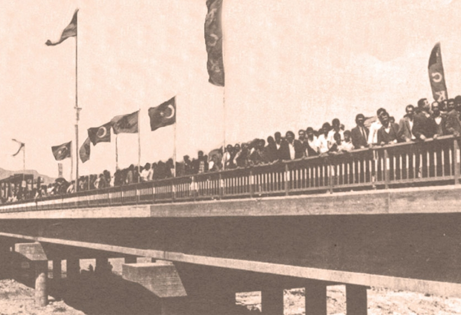
The opening of the “Umid” Bridge on May 28, 1992.
At the same time, Azerbaijan began actively using Iranian territory to connect with the exclave, which led to the opening of the Bilyasuvar checkpoint on the southeastern section of the border. In 2007, in addition to the existing Julfa crossing, a new Poldasht–Shakhtakhty checkpoint was opened on the northern section of the border between Nakhichevan and Iran.
In August 2004, Iran and Azerbaijan signed an agreement on gas supplies to Nakhichevan, which provided for compensation from Azerbaijan equal to the volume of gas supplied plus 15% for transit via the Astara–Abadan pipeline. This arrangement was implemented in 2005.
On March 5, 2025, the Igdir–Nakhichevan gas pipeline was commissioned, enabling the supply of Azerbaijani gas through Turkish territory (including a connection to the Trans-Anatolian gas pipeline). The additional capacity of this line has been increased to over 1 billion cubic meters, while consumption in the NAR amounts to about 350–400 million cubic meters annually. This makes it possible to export gas to Armenia via this route in the future, as connecting the gas infrastructures of the countries in this region is a relatively straightforward task for technical and geographical reasons.
Despite the isolation of the exclave’s railway system, the Azerbaijani side has also managed to maintain the operation of the railway infrastructure within Nakhichevan—on the Velidag–Nakhichevan–Ordubad section, that is, across most of the exclave’s territory. Since the early 2000s, passenger service has operated at varying intervals on the Mashhad–Nakhichevan route. Despite the deterioration of the infrastructure and limited possibilities for its restoration, this ensured that the railway system maintained minimal functionality under conditions of low traffic volume.
Part 10
Transportation Projects During the Freeze of the Karabakh Conflict: Adapting to Closed Borders
The example of the Nakhichevan Autonomous Republic clearly illustrates the transformation of transport communications in the South Caucasus during the frozen phase of the Karabakh conflict. In addition to the closure of transport links between Armenia, Azerbaijan, and Turkey, the suspension of transit through Abkhazia due to the conflict made direct rail service between Georgia and Russia (and, consequently, between Armenia and Russia via Georgia) impossible.
Following unsuccessful attempts to resolve the Armenian-Azerbaijani conflict in the late 1990s (during the tenure of Levon Ter-Petrosyan and the early years of Robert Kocharyan’s presidency), by the mid-2000s the parties had shifted toward developing alternative transport strategies. This took place against a backdrop of economic growth and an escalating arms race, which lent infrastructure projects significant geopolitical importance.
Azerbaijan has focused on developing east–west transport routes for exporting hydrocarbons to European markets, while Armenia has concentrated on the Armenia–Iran corridor and on seeking alternative links with Russia, including the Poti–Caucasus ferry route.
Both sides sought to integrate their projects into international initiatives and attract external financing, including through frameworks such as TRACECA, North–South, NABUCCO, and others. At the same time, Azerbaijan became more deeply involved in projects for alternative energy supply routes, which received support from Western countries, effectively excluding Armenia’s participation and cementing Georgia’s status as the region’s key transit hub.
Following this logic, the Baku–Supsa oil pipeline (1999), through which oil pumping was suspended in 2022, the Baku–Tbilisi–Ceyhan pipeline (2006), and the Baku–Tbilisi–Erzurum gas pipeline (2007). These projects allowed for the diversification of Azerbaijan’s hydrocarbon exports and strengthened Baku’s political influence in recipient countries, primarily in Southern Europe.
The route of these transport corridors, which bypass Armenian territory in a wide arc, has been replicated in other projects, such as the Kars–Akhalkalaki railway, becoming an important symbol of the region’s closed borders and a visual demonstration of the choice of less-than-optimal routes due to political factors.
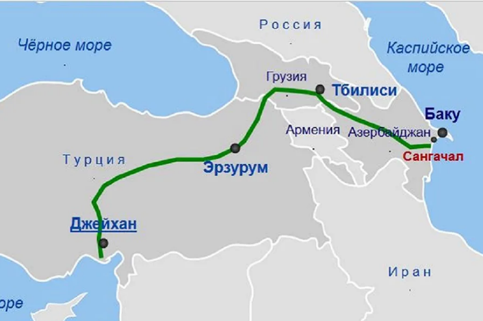
Schematic map of the Baku-Ceyhan oil pipeline.
Bypassing Armenian territory meant increasing the length of the routes (by at least 150 km) and raising construction costs, but it was viewed as a politically justified decision.
The key infrastructure project that cemented this strategy was the Baku–Tbilisi–Kars (BTC) railway. In terms of its configuration, it practically mirrors the Kars–Gyumri–Tbilisi line (288 km versus 292 km), but has a more complex profile, especially on the Tsalka–Akhalkalaki section, where three locomotives are required for traction.
The idea of building this line had been discussed since 1992–1993, but gained momentum in 1999, and construction began in 2007. Despite repeated delays (2010, 2011, 2013, 2014), which were linked both to the 2008 Russian-Georgian conflict and to the period of “soccer diplomacy” between Ankara and Yerevan. In 2017, the line was put into operation.
This marked the establishment of a direct rail link between Turkey and Azerbaijan through Georgian territory and became part of the China–Central Asia–South Caucasus–Turkey corridor.
The BTC project was initially positioned not as a regional route, but as part of a broader continental corridor within the framework of the “New Silk Road” (“Iron Silk Road”). Combined with the construction of the Marmaray Tunnel under the Bosphorus, this laid the groundwork for the formation of a continuous rail route connecting Europe, Turkey, the South Caucasus, Central Asia, and China.
It was emphasized that this route should restore transcontinental connections and strengthen Turkey’s role in land transport between the EU and China. This was particularly relevant given that, until 2022, approximately 90% of land transport between China and the EU was carried out via the Northern Corridor (Kazakhstan–Russia–Belarus–EU).
At the same time, the BTC was viewed as a key infrastructure for establishing broader transport connectivity between Turkey and Russia, including the use of the route to deliver grain from Russia and Kazakhstan by rail through the territory of Azerbaijan.
The Kars–Akhalkalaki Railway. Source — https://upload.wikimedia.org/wikipedia/commons/5/5e/Baku-Tbilisi-Kars_Railway_Map.svg
At the same time, land transport itself accounted for a negligible share of trade between the EU and China—about 3.1%—despite the growth in total trade volume from €401 billion in 2014 to €728 billion in 2024 (peaking at €858 billion in 2022). Attempts to offset significant time losses associated with sea transport (up to 60 days or more) have sparked interest in the potentially shortest land route between China and the EU via Central Asia and the South Caucasus.
China’s interest in developing alternative routes was manifested within the framework of the “Belt and Road” initiative, where the Trans-Caspian route was established as the China–Central Asia–Western Asia Economic Corridor (CCAWEC) in 2015—in parallel with similar efforts by Georgia, Azerbaijan, and Kazakhstan.
Part 11
The Impact of Russia’s Invasion of Ukraine on Regional Communications
A new wave of interest in China-initiated projects emerged after 2022—against the backdrop of Russia’s invasion of Ukraine and the imposition of sanctions, which led to a sharp decline in container traffic along the Northern Corridor (from 618,000 in 2021 to 330,000 in 2024). Under these circumstances, Chinese companies stepped up their involvement in the modernization of trans-Caspian infrastructure, including the expansion of the ports of Aktau and Alyat.
Kazakhstan, along with Azerbaijan, has become a key driver of this route’s development. Since the early 2010s, the country has consistently developed east-west transport links to the Caspian Sea, including the construction of new railway lines (over 2,000 km).
On November 7, 2013, at a conference dedicated to the “New Silk Road,” railway companies from Georgia, Azerbaijan, and Kazakhstan announced the creation of the International Trans-Caspian Transport Route, later named the Middle Corridor (as opposed to the Northern Corridor—through Russia and Belarus—and the Southern, maritime, corridor).
In 2014, ferry service began between the Kazakh port of Aktau and the Azerbaijani port of Alyat. In 2017, the new port of Kuryk was commissioned on the Kazakh coast, equipped with railway infrastructure and focused on transport to Azerbaijan.
The first container shipments via the Trans-Caspian Corridor began in 2019. However, the first demonstration shipments took 20–24 days to reach Georgia, which was significantly longer than anticipated. By the end of 2025, the total number of trains received had reached 466.
The ongoing modernization of Kazakhstan’s ports is expected to triple their container capacity by 2028. Against the backdrop of a decline in traffic along the Northern Corridor (to 330,000 containers by 2025), traffic volumes along the Central Corridor rose to 77,000 containers in 2025, significantly exceeding pre-conflict levels (just over 20,000 per year).
| Year | 2019 | 2020 | 2021 | 2022 | 2023 | 2024 | 2025 |
| Container traffic, thousand TEU | 26.0 | 21.0 | 25.2 | 33.6 | 20.2 | 55.0 | 77.0 |
Table: Growth in container traffic along the Middle Corridor from 2019 to 2025.
Despite the noted growth in traffic, the Caspian section remains the most vulnerable part of the Middle Corridor. Increasing traffic here requires not only a significant expansion of the cargo ship fleet but also improved efficiency of port infrastructure—primarily by reducing cargo handling and dispatch times on both shores of the Caspian Sea. Currently, it is this segment that is causing the key delays along the entire route.
In contrast, the route through Kazakhstan–Russia–Belarus constitutes a continuous land corridor within a single customs area, which ensures significantly more stable logistics. Even amid the war, freight volumes on the Northern Route remain substantially higher: in 2024, 10,546 trains were dispatched from China to Europe, of which only about 300–358 traveled via the Middle Corridor.
An additional constraint is the ongoing drop in the water level of the Caspian Sea (by 20–30 cm annually), which particularly affects the shallower Kazakhstani coast and requires constant dredging in ports, increasing costs and reducing the predictability of shipments.
Despite the growth in traffic, a significant portion of it in the South Caucasus still does not pass through the Baku–Tbilisi–Kars railway—which could speed up delivery times—but instead goes through Georgian ports. This significantly complicates logistics, requiring up to four consecutive transshipments: from the railway to a ferry on the Kazakhstani coast, from the ferry to the railway in Azerbaijan, and then repeating the same cycle at Georgia’s Black Sea ports—followed by unloading onto railcars at ports in Bulgaria or Romania. As a result, the total time lost during module changes becomes comparable to the train’s travel time and, in some cases, even exceeds it.
Thus, the average time a container spends in the ports of Aktau and Kuryk is estimated at 5–12 days, excluding vessel waiting time, whereas the actual downtime, including queues, can reach 7–15 days. Meanwhile, the crossing of the Caspian Sea itself takes about 1.5–2 days. On the Azerbaijani side, the situation is exacerbated: according to World Bank estimates, the total transit time for cargo through the port of Alyat can reach 27 days, making it one of the key “bottlenecks” of the route.
Similar problems are observed on the Black Sea section. In 2022, the average transit time for cargo through the Port of Poti was about 12 days, and through the Port of Batumi ( ) — up to 17 days. Thus, the Caspian-Black Sea segment accounts for the bulk of the time losses on the route.
This explains why, according to World Bank estimates, the total delivery time for cargo along the Middle Corridor in 2023 was approximately 38–53 days, whereas with optimized port infrastructure and reduced transshipment times, it could be reduced to 19–23 days, and in an optimal scenario, to 14–18 days.
In this context, the limited effectiveness of alternative Black Sea routes for Armenia becomes clear. The Poti–Caucasus rail-ferry service, launched in 2007, never became a full-fledged replacement for Upper Lars, as additional transshipments and port delays (up to 45 days) made this route unprofitable, especially for commodity groups that could spoil in transit (fruits, flowers, vegetables, fish, etc.).
| Year | BTC, million tons | Central Corridor, million tons | BTC Share, % |
| 2019 | 0.110 | 0.759 | 14.5 |
| 2020 | 0.225 | 0.783 | 2.7 |
| 2021 | 0.470 | 0.586 | 80.2 |
| 2022 | 0.432 | 1.485 | 29.1 |
| 2023 | 0.127 | 2.764 | 4.6 |
| 2024 | 0.098 | 4.484/3.3 | 2.2/3.0 |
| 2025 | 0.363–0.429 | 4.119 | 8.8–10.4 |
Comparison of freight volumes on the Baku–Tbilisi–Kars railway and the Middle Corridor, and the share of Baku–Tbilisi–Kars traffic in total Middle Corridor traffic.
Thus, despite the growth in freight traffic along the Middle Corridor from 2019 to 2025, the more time-consuming route via Black Sea ports remained the primary one, while the share of traffic on the BTC decreased, including in absolute terms.
The reasons for the limited effectiveness of the Baku–Tbilisi–Kars (BTC) railway are complex. On the one hand, they are related to the challenging route profile, particularly on the Tsalka–Akhalkalaki section, in contrast to the more convenient double-track Baku–Tbilisi–Black Sea ports route. On the other hand, significant time losses arise from the change in track gauge from “Russian” (1,520 mm) to European (1,435 mm) at Akhalkalaki. An additional factor is the harsh climatic conditions of the Javakheti Highlands, which complicate the operation of the railway during the winter months.
The desire to integrate the BTC into the emerging international transport corridor likely led to overestimates of its capacity during the design phase and in political statements. Thus, it was assumed that upon commissioning, the road would be able to transport 4–6.5 million tons of cargo annually, with subsequent growth to 17–20 million tons. Passenger traffic was estimated at 1 million people per year, with the prospect of increasing to 5–6.5 million (with a target of 3 million passengers and 17 million tons of cargo by 2030).
Actual figures turned out to be significantly lower. At the time of opening, the actual throughput capacity was about 1 million tons per year. Passenger service was never launched during the entire period of operation. Despite the modernization carried out by the Azerbaijani side in 2023–2024, which increased the road’s potential capacity to 5 million tons, actual traffic remains limited. The key bottleneck is the Turkish section—the Divrigi–Erzurum–Kars–Georgian border line, approximately 660 km long—which remains non-electrified, technologically outdated, and in need of modernization of its signaling and control systems. Even if the entire volume of cargo from the Middle Corridor were routed through the BTC, it would hit a bottleneck in Kars on a 660-km section with a maximum capacity of 0.75 million tons.
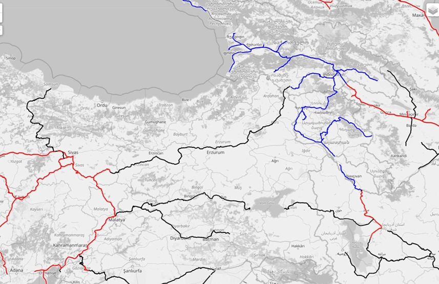
Map of electrified (color line) and non-electrified (black line) railways of eastern Turkey and western part of the South Caucasus. Source — https://www.openrailwaymap.org/
Turkey’s modernization program for this section calls for $1.6 billion in World Bank financing and completion of the work by 2030, which would potentially increase capacity to 20 million tons. However, modernization has not yet begun, which means that infrastructure constraints will persist in the medium term.
Under these conditions, the expected growth in traffic along the Middle Corridor (to approximately 11 million tons per year by 2030) will largely be redirected toward alternative routes—primarily through Georgian Black Sea ports, as well as road transport. This, in turn, means that significant time costs will persist and reinforces the corridor’s dependence on Georgian infrastructure, reducing the transit role of the Turkish route.
In turn, the inclusion of Turkey and its ports—where cargo handling costs are significantly (up to 40%) lower than at Georgian ports—into the road transport chain within the Middle Corridor can only be economically justified if routes are opened using Armenian territory. Since 96% of cargo is transported by road through eastern Turkey, and only 4% by rail, the prospect of new routes through Armenian territory for transit freight transport within the Middle Corridor could make a significant contribution to the growth of freight flows through Turkish territory. The geographical characteristics of the two countries inevitably require entry into Turkish territory. Moreover, the northern route through Armenia is the shortest and most convenient: the Gazakh–Ijevan–Vanadzor–Gyumri–Kars route (approximately 250 km and 4 hours and 20 minutes at this stage, while modernization of the route could reduce travel time by another hour and a half). This is approximately 120 km shorter than the alternative route through Georgia (Gazakh – Tsalka – Akhalkalaki –Kars (about 375 km and 6 hours 45 minutes), which is also characterized by more challenging terrain and periodic traffic restrictions during the winter, leading to the almost inevitable rerouting of cargo destined for Georgia toward Black Sea ports.
(To be continued)