


Samvel Meliksetian
Foreword
Following the 44-day war of 2020, the issue of reopening transport routes became one of the key items on the bilateral agenda between Armenia and Azerbaijan, while also being a crucial issue on the political and economic agenda of the South Caucasus. Although the opening of the Armenian-Azerbaijani and Armenian-Turkish borders has been discussed since the 1990s in the context of initiatives such as TRACECA, the East–West Corridor, and the North–South Route, and later the Middle Corridor, “One Belt, One Road,” and the European Global Gateway and TEN-T programs, the practical implementation of many projects continued to be hampered by the consequences of the conflict and closed borders.
As for analytical materials on the topic of unblocking communications, a significant portion of these publications often contained factual inaccuracies, politicized perspectives, or examined individual routes outside of a broader historical and regional context. In this context, this paper represents an attempt to offer a more comprehensive view of the South Caucasus’s communications challenges, to trace the influence of the imperial and Soviet legacies on the region’s modern communications system, and to examine current discussions on the prospects for the restoration and development of transport links in the current context, including the signing of the Washington Declaration on August 8, 2025, and the TRIPP initiative.
The paper examines how historical circumstances shaped the region’s current transport network, how the logic of routes has evolved, and why many existing transport links remain suboptimal from the perspective of regional connectivity. At the same time, it proposes a comprehensive and multi-variant approach to unlocking routes, based not on creating a single option or a narrow transport corridor, but on the widest possible use of all existing and potential routes, taking into account both the geographical aspect and the practicality of choosing transport modes—rail, road, and energy. Particular attention is paid to the possibilities of integrating the South Caucasus’s transport networks with those of neighboring countries—with which connections did not develop during the Soviet period for political reasons (Iran, Turkey)—as well as synchronizing them with European transport and logistics initiatives, including the TEN-T, Global Gateway, and Solidarity Lanes programs. In this context, the article examines the prospects for cooperation with the European Union, the development of multimodal routes, and the modernization of the region’s infrastructure.
The historical context examined in the article provides a better understanding of the logic behind current processes and the need to seek solutions that will allow for the most effective use of the South Caucasus’s transport and logistics potential—both for intra-regional connections and for its integration into geographically broader communication systems.
The Middle Ages
Communication networks in the South Caucasus have historically formed and transformed under the influence of trade and economic ties and political factors that determined the direction and intensity of traffic flows. The complex mountainous geography significantly limited possible routes, concentrating them in the valleys of major rivers (the Kura and Araks) or directing them toward rare mountain passes (Daryal) or narrow coastal corridors (Derbent).
The key transit route passing through the region in antiquity and the Middle Ages was part of the so-called Great Silk Road. It followed the Araks (Araz) Valley, crossed the river near Julfa (where a bridge had existed since antiquity and had been rebuilt several times), and then headed northwest along the Julfa–Nakhichevan–Yerevan — Kagyzman — Erzurum — Amasya — Constantinople (Istanbul). Branches led off from this route to other centers in the South Caucasus.
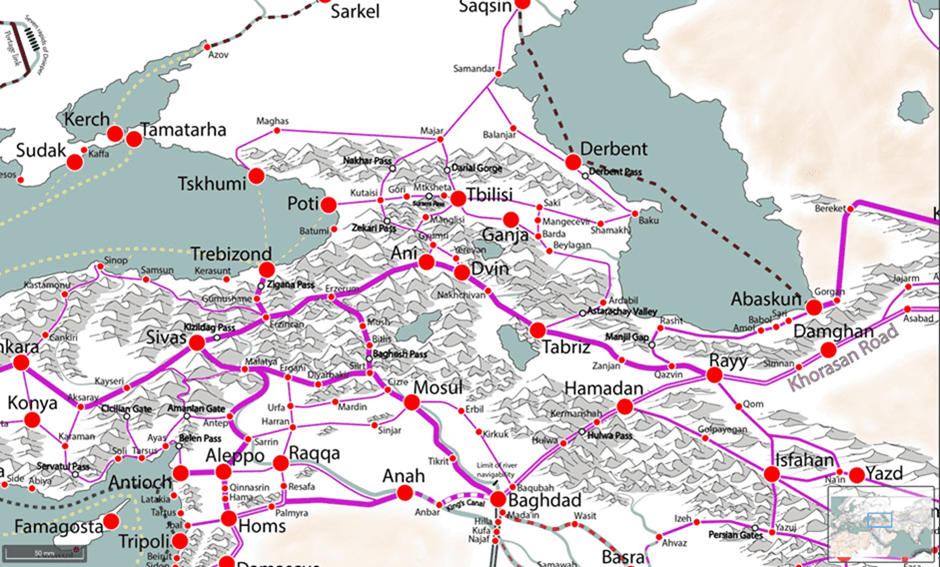
Excerpt from Martin Manson’s map of medieval trade routes: one of the main trade routes from Iran to China—through Central Asia, Armenia, and Byzantium—runs through the Araks Valley.
Transverse routes between the territories of modern-day Armenia and Azerbaijan passed through the mountain valleys of the Araks and Kura river basins (the roads from Vayots Dzor to Sevan to the Terter River Gorge and from Dvin to Partav/Dabil to Bardaa, according to Arab sources), however, they did not follow the course of the Araks River: in particular, the Julfa–Meghri section historically did not function as a through transit route.
The importance of these routes increased during periods of political stability across vast territories—primarily under the conditions of stable empires that ensured security and relatively low trade costs. Conversely, the collapse of imperial systems and regional crises led to the degradation of transit functions and a reduction in international transport.
The importance of the Julfa–Nakhichevan–Yerevan–Erzurum route grew once again in the 16th and 17th centuries, when trade in “Eastern goods” (primarily silk) through Persia and the Ottoman Empire to Europe reached a significant scale. This was accompanied by the growth of commercial, artisanal, and administrative centers along the route—such as Yerevan, Nakhichevan, Julfa (Juga), and Agulis.
However, as early as the 18th century, the development of sea routes and the deterioration of the political situation in Persia and the Ottoman Empire led to a crisis in transcontinental trade. As a result, the former routes lost their significance, communications took on a predominantly local character, and many previously important centers fell into decline.
The Russian Empire and the New Logic of Connections in the Region
The situation changed during the Russian Empire, which began its conquest of the South Caucasus in the late 18th and early 19th centuries. The need to integrate the region with the metropolis, the deployment of regular European-style armies with heavy artillery and supplies, the presence of a large corps of mountain engineers, as well as the desire to secure access to trade with India via the South Caucasus (an idea particularly popular until the 1840s) led to the large-scale road construction undertaken by the empire in the region.
An additional factor was the transformation of Tbilisi (Tiflis) into the de facto capital of the Russian Caucasus (the Caucasus Governorate), with the concentration of administrative, military, and economic functions in the city, which shaped a new logic of regional connections. As the common saying goes, all roads in the South Caucasus led to Tbilisi, which, in turn, served as the primary hub for communications with the heart of the empire. In this sense, the name of the main artery connecting the European part of the empire with the region’s main city—the Military Georgian Road—is telling, reflecting both the empire’s priorities and the lens through which it viewed the South Caucasus. From Tbilisi, highways branched out and headed toward the outskirts of the new imperial periphery.
One example of such imperial infrastructure development for military-administrative and commercial purposes is the Yerevan–Dilijan–Tbilisi highway. During the Russo-Persian wars of the early 19th century, the Russian army used a route from Tbilisi across the Lori Plateau (Tashir–Stepananavan–Vanadzor–Spitak–Aparan–Ararat Valley) to reach the Ararat Valley; this route crossed numerous gorges and passes and was unsuitable for reliable communication. Consequently, following the conclusion of the Russo-Persian War of 1826–1828, construction began on a new highway via Dilijan, running through the more accessible valleys of the Aghstev (Aghstafa) and Kura rivers toward Tbilisi. While the previous route required crossing three difficult mountain passes, as well as the deep gorge of the Dzoraget River ( ), the new route had only one pass—the Sevan Pass. On both sides of it, the Russian authorities settled Russian settlers (Molokans, Dukhobors, and, less frequently, Orthodox Christians) in Dilijan, Semenovka, Yelenovka (Sevan), Fontan, Konstantinovka (Tsaghkadzor), and other locations with the aim of creating a reliable demographic base along strategic communication routes. Molokans and their wagons also served as the primary transporters on the most difficult sections of this route until the early 20th century.
Russian official Ivan Schopen, who compiled a detailed description of the Armenian region in the 1830s, wrote about the purpose of the new road, outlining the administrative and commercial goals of the project:
“This road is not yet finished: it is intended to be the main route between Georgia and Persia, through the Armenian region, with the postal stations of the Gyumri route also transferred to it. This road will be one of the most magnificent monuments to Russian rule… Along this road, the distance from Tiflis to Erivan will be 220 versts of comfortable carriage travel. With it, commercial relations with Persia and India will be revitalized…”.
However, protectionist measures to restrict the so-called Transcaucasian transit—the trade route from Europe and the Ottoman Empire to Persia through the Araks Valley—in the 1840s led to a significant reduction in the volume of international trade through the region and a strengthening of its ties with the empire’s internal centers.
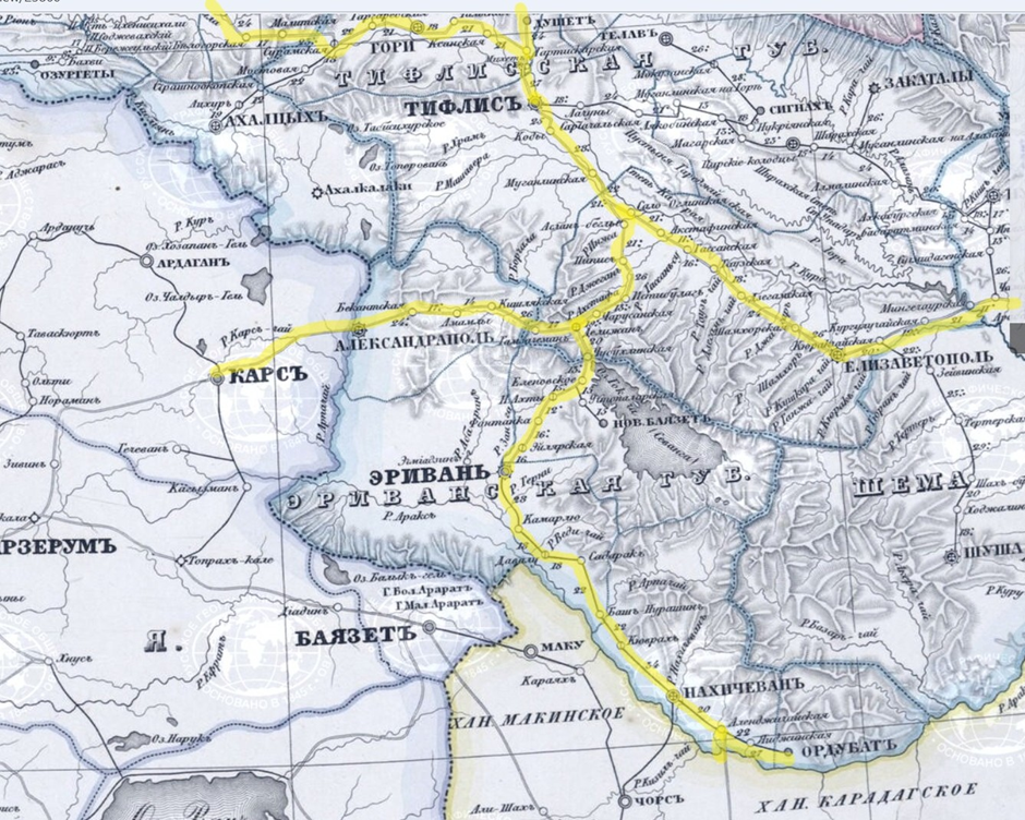
Excerpt from an 1852 postal map of the Caucasus region showing major roads.
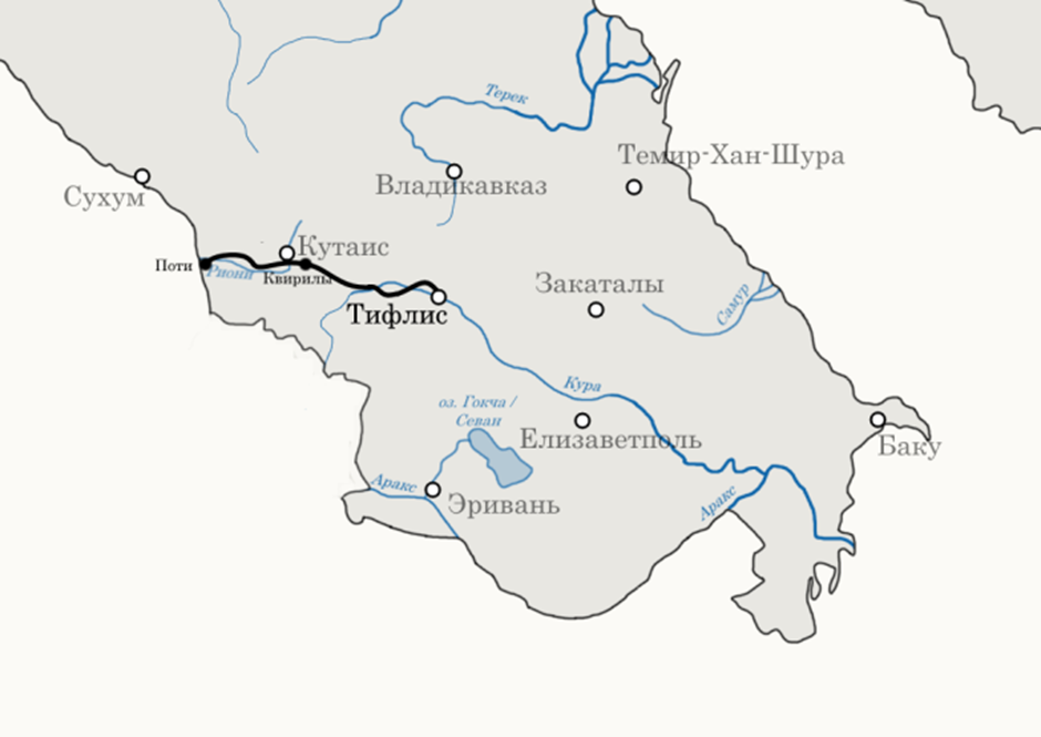
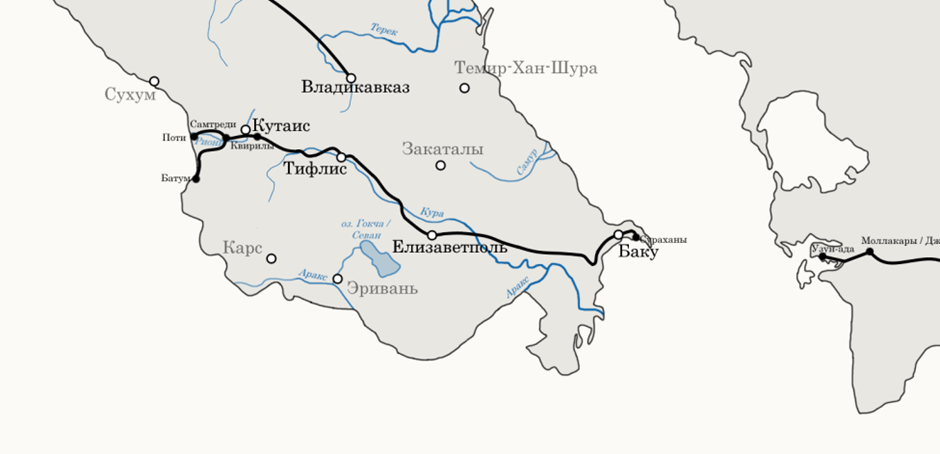
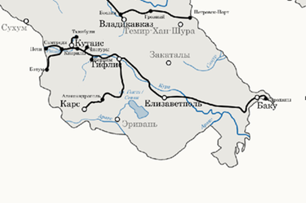
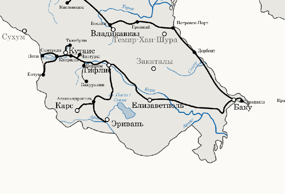
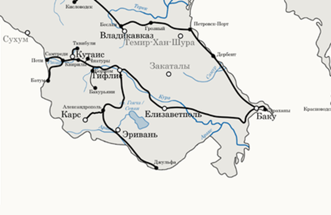
The priority given to connections via Tbilisi was also reflected in railway construction. The first railway in the South Caucasus linked the port of Poti with Tbilisi (1872). At the same time, the section of the railway crossing the Surami Pass became the most challenging in the empire in terms of terrain (a gradient of 46 meters per 1,000 meters of elevation) and required traction from special articulated Ferli locomotives, which is why, later, in the 1880s, a tunnel had to be built. With the start of commercial production of Baku oil in the second half of the 1870s, the line was extended to Baku (1882), forming the region’s key railway artery from the Caspian to the Black Sea. By 1900, the Transcaucasian Railway had been connected to the Vladikavkaz Railway, which stretched from Rostov-on-Don to the Caspian coast, forming a continuous main line that linked the South Caucasus with the central regions of the empire.
With the capture of Kars and Batumi in 1878, serious consideration was given to the idea of building railroads to these locations—the most important port in the South Caucasus and a key fortress on the border with the Ottoman Empire. By 1883, the Poti–Batumi railway had been built , and by 1899, the Tbilisi–Alexandropol–Kars line.
The choice of the latter’s route resulted from a conflict between engineering rationality and investor interests: engineers proposed a more optimal route along the Aghstev Valley: from Aghstafa Station through Dilijan—Karakilisa (Vanadzor)—Alexandropol to Kars. However, in the end, a significantly more complex and costly option through the Debed River Gorge (Lori Gorge) was implemented. The reason for this was the interests of the French concessionaires of the Alaverdi copper mines, who were keen for the railway to pass through the area of their economic activity. As a result, the Lori section of the railway also became one of the most challenging in the empire, requiring complex engineering solutions, such as the 170-meter-long Zamanli Viaduct, which served for over 100 years.
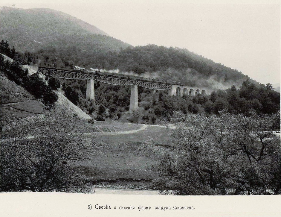
The Zamanli Viaduct over the Vahagni River Gorge.
The outcome of the Franco-Prussian War of 1871 demonstrated that railways were a key instrument of military planning and the rapid deployment of troops to potential theaters of war. Rail transport became the primary mode of communication, opening up new opportunities for both the economy and the military sphere, as well as for the expansion of political influence. It is no coincidence that the Ministry of War played a leading role in the construction of new railways in the South Caucasus, as its projects often conflicted with economic or administrative considerations. Thus, the Russian Empire’s growing interest in Persia in the early 20th century led to active discussion of railway routes heading south. Ultimately, the route along the Araks Valley to Julfa was chosen. However, despite the route’s proximity to Yerevan, the military initially did not consider it necessary to include the city in the main line: only after persistent appeals from the city council was a decision made to build a branch line from the Masis (Ulukhanly) station to Yerevan.
1872
1882
1899
1902
1908
Construction of railways in the South Caucasus from 1872 to 1908 (source- Geographer’s Notes blog – https://zametki-geo.livejournal.com/)
(To be continued)