


Border issues between Armenia and Azerbaijan have always maintained their relevance, existing long before the emergence of the two contemporary states. The border between the first independent republics in 1918-1920 remained fairly conventional up until their Sovietization. And even after this, border issues between the “brotherly” Soviet republics remained subjects of dispute and continuous review throughout the seven decades of the USSR’s existence. Issues related to transport communications, water resources, pastures and other factors served as grounds for changing the administrative boundaries between Armenian and Azerbaijani SSRs. As the time progressed, enclaves belonging to the neighboring country began to develop within the territories of both republics, spanning virtually the entire border. Already during the period of restoration of independence, these areas became centers of additional tension and military clashes between the sides. In this context, reflecting on similar conflict situations triggered by the presence of enclaves that were also formed in Soviet times among the autonomies of the North Caucasus and the republics of the Central Asia, one can confidently assume that the “enclave” policy was “invented” by the central authorities of the USSR in order to curb the centrifugal aspirations of the union republics.
In one way or another, subsequent to Armenia and Azerbaijan gaining de facto independence, the borders of these states underwent a number of changes as a result of the bloody wars of the early 1990s and post-2020. Simultaneously, a prevalent sentiment took hold in both societies that all past border changes occurred unjustly, favoring the opposite side.
At this stage of the conflict, with Baku, Yerevan and a number of international players talking about a historical opportunity for achieving lasting peace, the issue of border delimitation becomes particularly important. If there is a shared belief that the most legitimate method for defining the border is to reference the 1991 Alma-Ata Declaration as a fundamental document, then the constructive discussion on the issue of enclaves, the facilitation of effective economic activity and the security of border areas assumes fundamental importance.
The article by political scientist Samvel Meliksetyan presents the historical and politico-legal factors surrounding the establishment of the Armenian-Azerbaijani border, contradictions among various maps and a detailed description of the enclaves. The author provides his perspective on the delimitation process, intending to ensure that the borders do not turn into a time bomb threatening the future of the two states.
Delimitation pitfalls
The issue of delimitation and demarcation of the Armenian-Azerbaijani border is associated with a number of interconnected topics that become part of an active and highly politicized discourse within the media, among politicians and experts in both Armenia and Azerbaijan. Not only do political declarations regarding delimitation principles undergo periodic changes, but there is also a lack of a clear vision regarding the problem and its potential solutions. It is noteworthy that despite the fact that the delimitation and demarcation issues are frequently mentioned in a unified context, it is the first stage that is associated with the most intricate set of contradictions (including political ones), while the second stage, though time-consuming, is mainly challenged by technical and local complexities.
Even without considering political and military factors, the Armenian-Azerbaijani border emerges as one of the most complicated in the post-Soviet space. It is the longest in the South Caucasus (about 1000 km in length, and is comparable, for example, with the Belarusian-Ukrainian border (1084.2 km)). Characterized by highly rugged terrain, it crosses through numerous mountain valleys and ridges, infrastructure such as roads, mineral deposits, reservoirs, canals, reserves, etc., includes enclaves, pene-enclaves and narrow strips of land extending into the territory of the neighboring state. The complexities were further compounded in the 1990s and after the war of 2020, when both sides occupied a part of each other’s former administrative territories. In the 1990s, these actions were primarily driven by the necessity to ensure uninterrupted transport links (roads connecting different parts of the territory of Armenia or Azerbaijan often crossed the border and passed through the territory of the neighboring state) and the safety of border villages.
Added to that, the extremely rugged terrain along the border significantly extended its length and rendered its defense problematic in the case of armed confrontation. That is why, in the 1990s the border was “straightened” and almost all protruding parts were eliminated (as was the case in the north). Concurrently, enclaves vanished from the actual map of the region during this period, engulfed by the surrounding state (with the exception of two tiny Azerbaijani exclaves near the village of Yaradullu, which remained under the control of Azerbaijan along with the entire surrounding territory of Armenia). The Armenian forces took control of a height, ensuring the security of the villages of Berdavan and Dovegh, villages along the Noyemberyan-Ijevan highway (Kheyrimli, Ashagi (Lower) Askipara and Baghanis-Ayrum), and unblocking communications in the northeast of Armenia. And Azerbaijani forces took control of a large protruding area of Armenian land (approximately 7 km²) north of the Joghaz Reservoir. This territory encompasses the highway linking villages of Kushchi-Ayrum and Mazam with Azerbaijani “mainland”. Furthermore, the Azerbaijani armed forces took control of the protruding large pieces of Armenian territory between the villages of Paravakar, Yaradullu, Kohnaqislaq (approximately 8-10 km², including two micro-esclaves of Azerbaijan located west of the village of Yaradullu), the territory north of the village of Vazashen (more than 6 km²), through which the highway connecting the village of Bala Jafarli with the rest of Azerbaijan runs. They took control of almost all the heights along the eastern border of former Shamshadin region, where small Azerbaijani villages were situated, and Armenian military posts had to be set up much deeper into Armenian territory, at a distance of more than one kilometer from the Soviet-era administrative border. A similar scenario unfolded in Nakhichevan area, marked by the struggle for the control over the heights of the high-mountain Zangezur range (where the 1990s were relatively calm, but the situation escalated in the 2010s). By the mid-1990s, Armenian forces took control of a section of territory along the highway spanning from Ararat region to Vayots Dzor, including the abandoned village of Gunnut (of which, in turn, Azerbaijan partially regained control in May 2018), and Azerbaijani forces took the heights north of the village of Sadarak (the origin of fire directed at the metallurgical plant under construction in Yeraskh in 2023), the southern end of the protrusion of the village of Khachik and a number of other areas.
Between January 1990 and August 1992, for similar reasons, the involved parties seized control of exclaves/enclaves. Consequently, by the initial years of independence the real Armenian-Azerbaijani border only roughly corresponded to the old administrative border. Additionally, a neutral zone emerged between the lines of trenches and stronghold fortifications of the sides (sometimes extending up to 1.5-2 km wide), which rendered a significant portion of the border area of the two countries inaccessible to the civilian population, hampering agricultural and other economic activities. This loss was particularly painful for Armenia, given that the most densely populated and fertile foothill areas in Tavush marz (region), prized for farming and gardening, lie adjacent to the border, a stark contrast to the neighboring lowland Azerbaijani regions (Ghazakh, Aghstafa, Tovuz), where the same zone is mountainous and less populated.
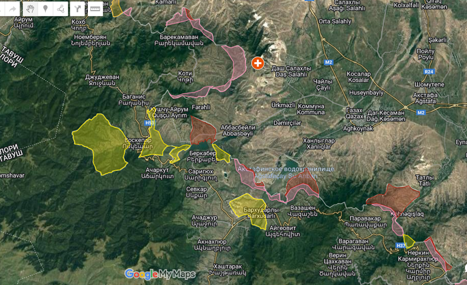
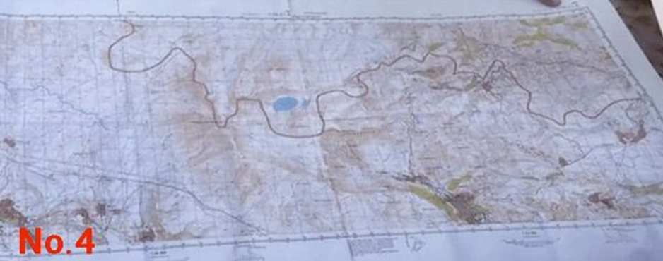
Map 1: the situation in the northeast of Tavush region of Armenia
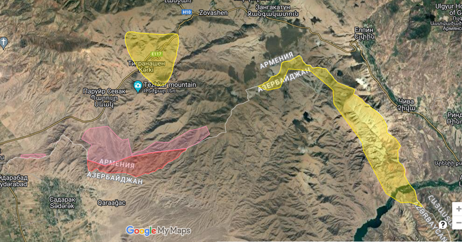
Map 2: the situation in the north of Nakhichevan Autonomous Republic
The territories within the borders of the former Azerbaijani SSR (including the enclaves of Yukhari (Upper), Askipara (Verin Voskepar), Sofulu-Barkhudarly and Kyarki (Tigranashen)), which have been under Armenian control since 1990-94, are highlighted in yellow. The territories of Armenia falling within its borders, but located beyond the line of Armenian trenches (neutral territory, not under anyone’s control), are highlighted in pink. The territories of Armenia under the control of Azerbaijani forces are highlighted in dark red.
Substantial tracts of land were mined, some of which weren’t even marked on maps. This challenge is anticipated to persist long, even after interstate relations are normalized, and border delimitation and demarcation are completed.
Since 2021, another zone has emerged along the eastern and south-eastern border of Armenia with Azerbaijan, stretching from the Sotk (Zod) deposit to the village of Nerkin Hand south of the city of Kapan. Here the border territory of Armenia is penetrated to a depth of 4-5 kilometers.
Even setting aside the territories taken control of during the clashes of the early 1990s and in 2021-2022, the Armenian-Azerbaijani border can be categorized into two differing sections, with varying complexities (technical, political, demographic, and communication-related hurdles) that will present challenges during delimitation. On the one hand, this is the border segment along ridges and highlands stretching from Chambarak in the northeast to the village of Khnatsakh in the southeast of Armenia, as well as sections of the Zangezur range bordering Nakhichevan Autonomous Republic (NAR). Here, the border line predominantly follows watershed ridges, indicating that there should be minimal disagreement between the parties regarding delimitation principles. On the other hand, the most complex border fragments are found in Tavush and the eastern part of Syunik (from the village of Khnatsakh to Kapan), as well as in the northern areas of the NAR. They include enclaves, intricate border delineations, intersecting communication routes, reservoirs, etc.
The complex historical and political background, deepening mistrust and crisis in international relations obstruct the formulation of rational solutions based on similar precedents in the post-Soviet space. Consequently, even within expert circles there is often a lack of understanding regarding the methods of delimitation, the underlying principles, the selection of maps, the handling of enclaves, the management of cross-border roads linking different parts of a single country, and various other issues.
Since the wave of independence of former European colonies in Africa, the collapse of the USSR and the multi-partite states of the socialist bloc, determining the borders of the newly emerged states has been one of the key issues in international relations. From the 1960s onward, there was a growing adherence to the principle of uti possidetis juris, whereby the administrative borders within the former sovereign state (the borders of colonies, autonomous regions and other units within federal entities, the USSR republics, etc.) were acknowledged as the borders of new states. This principle was enshrined in decisions of the International Court of Justice regarding the borders of Burkina Faso and Mali (1986), as well as applied during the dissolution of Czechoslovakia, Yugoslavia and the USSR. It is noteworthy that this principle was acknowledged by the post-Soviet republics, including Armenia and Azerbaijan, upon signing the Alma-Ata Declaration on December 21, 1991. Even in those rare cases where this principle was violated, and the independence of sub-republican entities was recognized, these borders also followed the administrative border of the autonomous region within the former sovereign states. For instance, Kosovo’s borders mirrored the administrative boundaries of the autonomous region within the Serbian Socialist Republic, despite the fact that the northern part of Kosovo (Metohija) was dominated by the Serbian population. All processes of delimitation and demarcation in the post-Soviet space were also based on the recognition of the inter-republican borders during the final years of the USSR, which were refined and optimized only as a result of subsequent bilateral agreements. Following this principle, even in the absence of delimitation, the internationally recognized border of Armenia and Azerbaijan continues to be the former administrative border between Armenian and Azerbaijani SSRs, and its modification is possible only through mutual agreement, excluding the use of force.
References to the absence of delimitation between borders of certain countries, thereby impeding their exact determination, contradict the aforementioned principle and established practice. Moreover, even in cases where the delimitation process is not completed, countries are expected to adhere to the former administrative borders.
Maps selection issue
Following the emergence of the Armenian-Azerbaijani border delimitation issue in 2021, sharp contradictions immediately surfaced regarding the portrayal of borders by each party and the sources they referenced. While maps serve as the primary and most accessible source for understanding borders, the selection of maps has become a distinct problem, further complicating the situation rather than facilitating the resolution of the problem.
Within the Armenian discourse, there has been a notable propagation of the mythology of the so-called “maps of the 1920s” (more specifically, 1927-1929 maps, as cited by some politicians), where the Armenian side supposedly held more favorable positions. Despite these statements often stemming from experts and cartographers, they fail to take into account the poor quality of the cartographic materials of the early Soviet period and the issue of scale (all these maps are small-scale, resulting in border lines several kilometers thick when projected onto the ground) without linking it to the developed coordinate grid (completed in the UUSR only in 1942). Through such maps, it is simply impossible to determine the coordinates outlining the boundary and other geographical objects. Distortions and displacements of actual geographical contours extend to tens of kilometers in certain cases. Furthermore, the “mythology of maps of the 1920s” among all the available maps selectively employs only those indicating the “advantageous” contours of a specific area of the border, disregarding inconsistencies in other areas.
In the period following the Karabakh war of 1992-1994, the Azerbaijani side also actively utilized such maps to support the argument about the “aggressive intentions of Armenians” during the Soviet years. However, a comparison of maps published between 1922 to the mid-1930s reveals numerous contradictions.
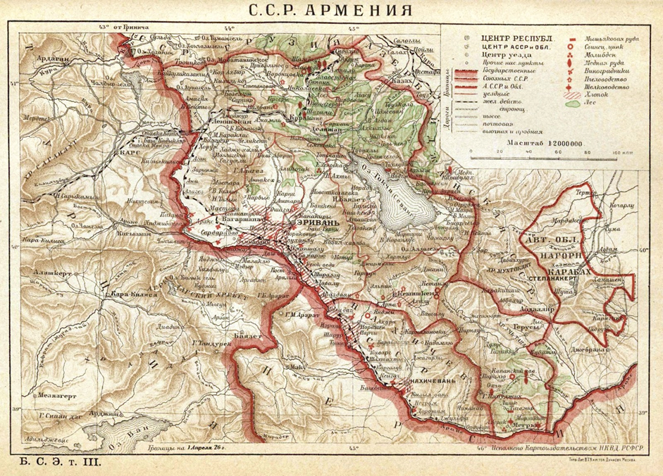
Map 3
As an example, we can refer to the map of the Armenian SSR found in the first edition of the Great Soviet Encyclopedia of 1926. A detailed version of the map is available for viewing via the following link: https://upload.wikimedia.org/wikipedia/commons/a/a4/Map_of_Armenian_SSR_from_the_GSE_of_1926.jpg
Here, within the Armenian territory, the village of Sadakhlo is marked, despite not being part of it, while the Armenia-Georgia border is shown to pass through the village of Bagratashen (then Lambala), although the entire village and the territory north of it have been part of the Armenian SSR since 1921. In the Artsvashen zone, the village itself appears to be situated on the Armenia-Azerbaijan border, while the upper part of the Getik River gorge with the village of Ordzhonikidze (now Vahan) established in 1925, is depicted as part of the Azerbaijani SSR. The Nakhichevan Autonomous Soviet Socialist Republic encompasses the villages of Khachik and Areni (formerly Arpa until 1946), despite evidence of these villages being part of Armenia. There is a misplacement of contours of the Zangezur range, the eastern border and rivers of Syunik region of Armenia. The shared border between Turkey and the Nakhichevan ASSR is not indicated, alongside a number of other errors.
It is noteworthy that on the map of the Azerbaijani SSR, found in Volume IV of the Great Soviet Encyclopedia from the same year, the northern border of Armenia is depicted significantly north of the actual border, extending as far as the present-day city of Rustavi on the Kura River. The low quality of early Soviet maps is understandable, given the lack of geodetic measurements, a developed coordinate grid, and the loss of a significant number of cartographers and land surveyors who served as officers in the tsarist army. It is not coincidental that until 1941, even the Red Army continued to reproduce sheets of the 5-verst map of the Tsar’s General Staff, whose quality also leaves much to be desired.
The materials of the inter-republican and federal (The Transcaucasian Socialist Federative Soviet Republic, TSFSR) commissions on land disputes and changes hold much greater significance in this regard. These documents include descriptions of the existing borders and disputed areas. Changes were actively taking place from the moment of the TSFSR establishment in 1922 until its dissolution in 1936, when the inter-republican borders had already solidified, closely resembling their configuration at the time of the USSR’s collapse. However, in general, these materials are useful only for identifying historical changes on the border, in some cases offering useful insights into past delimitation principles and processes. For example, one of the most acute land disputes between the Soviet republics of Armenia and Azerbaijan during this period was the issue of nomads and high-altitude pastures, which played a decisive role in the arbitration over a number of disputed territories (the Alagollar lakes area (known as the Al Lakes in Armenian) located south of Lake Sevan and transferred to Azerbaijan). However, this argument lost relevance by the second half of the 20th century and, of course, cannot hold substantial weight in delineating the modern border.
The Azerbaijani side, in turn, during its May 2021 advancement into the territory of Armenia (area spanning from Lake Sev to Ishkhanasar Mountain) presented maps identical to those of the Soviet General Staff. However, the border contours on these maps were distorted compared to the original Soviet versions. Wherever the Azerbaijani side could gain advantage from strictly adhering to accurate maps, it used them, for instance, in the case of the village of Shurnukh, part of which (13 houses) according to the maps of the Soviet General Staff was located in the territory of Azerbaijani SSR, and a section of Goris-Kapan highway, in some instances either crossing or following the former administrative border. Sticking strictly to this boundary led to the division of the village of Shurnukh and the blocking of the only broadband asphalt highway from Goris to Kapan, Meghri and further towards Iran.
Looking ahead, it is important to mention that such a decision (blocking communications within a country due to minor border crossings in a number of areas) violates the accepted delimitation rules. For example, during the delimitation of the borders of the Baltic states, Belarus and Ukraine similar issues were resolved through territorial exchanges, while preserving the roads and adjacent infrastructure for the party utilizing them. It is noteworthy that the Azerbaijani (by Soviet-era population) village of Shurnukh remained part of the Armenian SSR in the early 1920s precisely because the only highway from the northern and central parts of Syunik (Sisian and Goris) to Kapan ran through it.
The motive behind drawing borders with intersecting communications during the Soviet era, apparently, was the desire to maintain the inter-dependence of the republics and complicate their potential painless exit from the USSR. The placement of these mines quite effectively served its purpose, sparking conflicts between the involved parties and increasing the influence of external arbiters over them. It is essential to consider this factor to ensure that new decisions on delimitation minimize the border conflict risks and prevent further complication of intricate political relationships with geographical considerations.
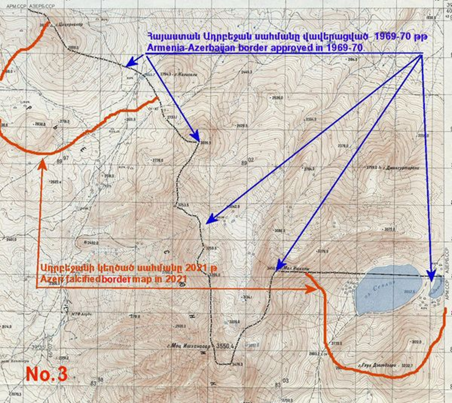
Map 4: the distorted border contours near Lake Sev and north of the Ishkhanasar Mountain massif, appearing as deeply wedged semicircles into the territory of Armenia, presented by Azerbaijani officers during the May 2021 advance of the Azerbaijani army into this area, and the actual border depicted on the map from the USSR General Staff (as documented by Ruben Galichian).
Since the end of 2023, the Azerbaijani representatives have increasingly relied on maps of the Azerbaijan Democratic Republic (1918-1920), rather than the maps reflecting actual territorial control. Instead, they refer to maps outlining its territorial claims at the Paris Peace Conference of 1919: these maps include such present-day areas as Tavush, Vayots Dzor, Syunik regions and the western shore of Lake Sevan.
Among the available options, a more meaningful and adequate political discourse revolves around the selection of maps of the Soviet General Staff of 1975, a preference reflected in the official proposals of the Armenian side since 2022. On the one hand, these maps offer a relatively precise depiction of the border between the two republics at the time of their publication. However, these maps suffer from purely technical drawbacks, including reliance on an outdated coordinate grid from 1942 (SK-42, necessitating conversion to modern universal standards). Furthermore, it is essential to take into account the inherent inaccuracies of the map itself and its scale (maps at a scale of 1:100,000 have a maximum error of approximately 150 m, while those at 1:50,000 – 75 m, etc., though these discrepancies on the ground generally amount to only a few dozen meters on average), as well as changes in the situation on the ground since the map’s publication (expansion of human settlements, soil erosion, deforestation, changes in river beds, etc.). During delimitation process, it will become imperative to update them and rectify the data accordingly. On the other hand, the maps of the General Staff in this case lack the comprehensive information needed for delimitation. Changes in administrative borders and their locations in the USSR were also documented by other maps, particularly those used for the western republics of the former USSR (Baltic countries, Belarus and Ukraine), which were the most prompt in carrying out delimitation. These include the so-called “standby maps”, published by the Territorial Inspectorates for State Geodetic Surveys (TISGS) of the Main Directorate of Geodesy and Cartography of the USSR, which documented changes in administrative boundaries and other necessary information for map creation. Cadastral maps, indicating the boundaries of state farms, forestry enterprises, and water management enterprises of bordering republics, also play a significant role. It is these sources that are cited in the advisory manual on delimitation and demarcation, published by the OSCE in 2017, drawing on the experience of border demarcation in the Baltic states and Belarus (available at: https://www.osce.org/files/f /documents/2/8/363471.pdf).
There exists another source for the delimitation of the Armenian-Azerbaijani border, which is extremely important due to its association with the execution of similar tasks in the later years of Soviet rule. It is the commission tasked with clarifying the border and regulations for economic activities in the border zone between the Soviet republics of Armenia and Azerbaijan, which has been operational with intermittent pauses since 1969. These activities intensified in the first half of the 1980s following a number of conflicts among residents of the border areas of the two republics. Acute and rather unprecedented conflicts for the USSR emerged during the commission’s operations, including the beating and hostage-taking of the Secretary of the Central Committee of the Communist Party of Armenia Vladimir Movsisyan and members of the Armenian delegation in the village of Kemerli, Gazakh district of Azerbaijani SSR in October 1984. These efforts concluded on January 12, 1988, with the signing of an inter-republican agreement, resolving controversial issues on the Armenian-Azerbaijani border. As the last agreed-upon version of the border before the declaration of independence, this source also contains a rich cartographic database, greatly facilitating the forthcoming delimitation endeavors.
The genesis of enclaves, demographics and communications in the border zone
In the process of delimitation of the Armenian-Azerbaijani border a notable concern arises regarding the enclaves and other territories under control, including the Azerbaijani villages of Ghazakh district outside the enclaves (Baghanis-Ayrum, Ashagi (Lower) Askipara, Kheyrimli, Qizilhajili), which are situated in the “neutral zone” or under partial control of Armenian side.
The genesis of enclaves is shrouded in a rich mythology, tracing back to the Soviet maps from early 1920s, a time when boundaries between the union’s republics were still actively debated. As already noted, most of these misconceptions and the replication of these myths stem from experts and cartographers who, for various reasons, fail to critically analyze primary source data.
An important problem, as highlighted earlier, is the poor quality of the Soviet maps of the 1920s, which, for example, led to a number of widespread misconceptions, including regarding the shared border between SSR Armenia (later Armenian SSR) and the AONK (later NKAO, Nagorno-Karabagh Autonomous oblast/region), the absence of a shared border between Turkey and the Nakhichevan ASSR until the 1930s, and the belief that the settlements that became Azerbaijani enclaves in Armenia originated solely in the 1930s through the resettlement of Azerbaijanis, etc. However, all of the listed small villages with Turkic populations existed already by late 19th century and were documented in various statistical works of the Russian Empire era. For instance, by 1886, the villages of Sofulu (population 103) and Barkhudarly (population 69) were listed as part of the Uzuntal rural community within the First police station of the Kazakh Uezd (county) of the Elizavetpol Governorate.
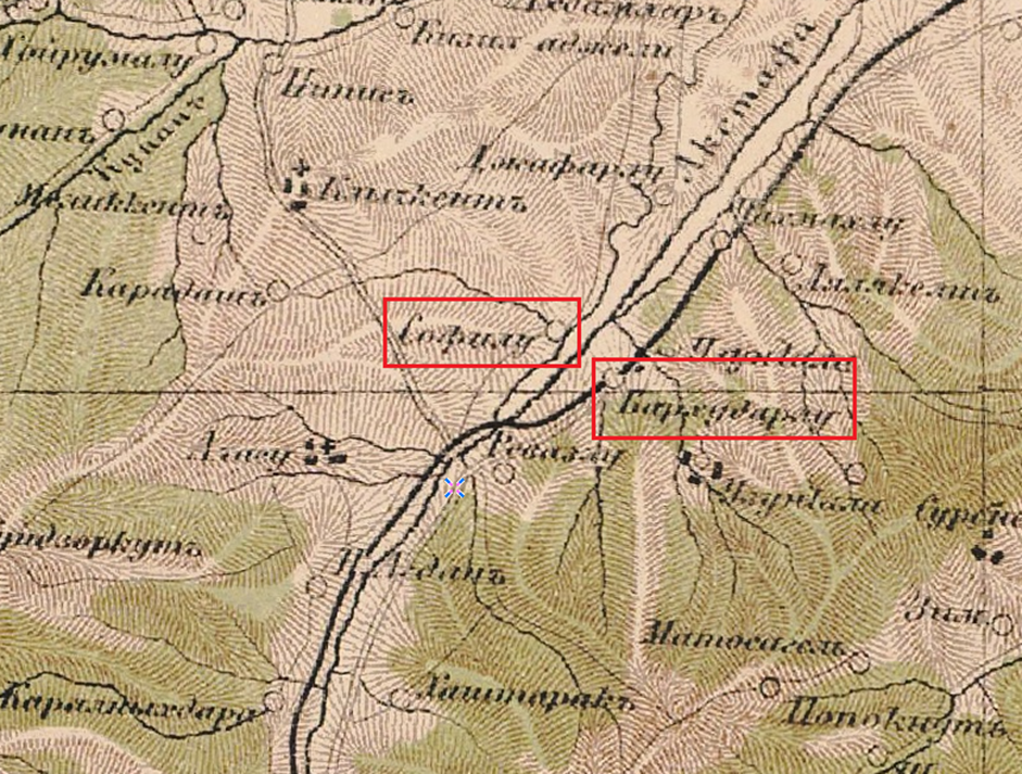
Map 5: the Strelbitsky map of 1871 depicting the small villages of Sofulu and Barkhudarly with Turkic populations
Map 6: distribution and size of Armenian (highlighted in red) and Turkic villages in the Kazakh Uezd at the close of the 19th century (compilation of statistical data on the population of Transcaucasian region, extracted from family lists of 1886). Author – S. M.
A higher resolution map is available here.
The most remarkable situation in this regard unfolds in the Voskepar zone, particularly concerning a cluster of small Turkic villages (Kushchu-Ayrum, Mazam, Kheyrimli, Upper and Lower Askipara, Baghanis-Ayrum), situated along the narrow valley of the Voskepar River. This area forms a thin strip wedged between the large Armenian villages in the mountainous zone (present-day Tavush) to the north and south. In 1918-1920 armed conflicts took place around these villages, intensifying notably from July 1920, when the upper part of the Voskepar River valley became a scene of clashes between the Armenian army and Red Army units. Despite an agreement reached on August 10 in Tbilisi between the governments of the Armenian Republic and the Soviet delegation, stipulating that the Kazakh zone would maintain the line of control by July 30, 1920 (the villages of Mazam, Kushchu-Ayrum, Baghanis-Ayrum and Askipara were under Armenia’s control, since communication between northern and central parts of present-day Tavush was ensured), the Red Army violated the treaty the following day and invaded Armenia. This circumstance served as a basis for drawing the Soviet-era border line between Azerbaijan and Armenia. Be that as it may, in this and in all other cases, the principle of following administrative boundaries post the collapse of multi-partite states and altering them solely through mutual consent would be the most promising and least conflict-prone approach.
The Soviet delimitation in the territory of former Kazakh Uezd was guided by an approach where the entire mountainous part of the Uezd (present-day Tavush, Chambarak subdistrict of Gegharkunik region) with a predominantly Armenian population passed to Armenia, while the plains inhabited by Muslims passed to Azerbaijan. The only exception was the zone of numerous small kishlaks in the upper reaches of Akhinja River, within the mountainous area known as Shynykh-Ayrum community. Although initially part of Armenia, this area was transferred to Azerbaijan during land disputes in the 1920s, leading to the isolation of the village of Artsvashen from the west. The descriptions of the borders and land disputes between Soviet Armenia and Azerbaijan in 1922 already suggest that the village of Yukhari (Upper) Askipara, as well as Sofulu and Barkhudarly were attributed to Azerbaijan, although their border with neighboring Armenian villages remained uncertain for a considerable period.
To understand the genesis of the enclaves, a crucial resource is the highly detailed 2-kilometer map from this era, illustrating accurate boundaries and contours based on republican geodetic measurements. This map was released by the State Publishing House of the Armenian SSR in 1932. It is interesting here that the designated villages of well-known enclaves (Yukhari Askipara, Sofulu, Barkhudarly), although depicted inside Armenia, are highlighted using the font commonly associated with the villages of neighboring republics (i.e., the Azerbaijani and Georgian SSR). It is also noteworthy that the territory of Artsvashen (Bashkend), which shares a border with the Armenian SSR, although highlighted with a thin dotted line, is positioned beyond the outline of the republican border, while the name of the village is indicated in a font characteristic of villages in Armenia. This serves as a good illustration of how the villages’ affiliation with specific republics was widely understood, yet the borders of these villages with the surrounding territories of Armenia and Azerbaijan for each enclave remained subject of debate.
See the full file size at the following link: https://shorturl.at/rwzAM
It is worth noting that such strict adherence to the ethnographic principle in Tavush zone, even when large Armenian border villages were connected through small Azerbaijani villages (Voskepar or Sofulu-Barkhudarly zone), was uncharacteristic of the Armenian-Georgian delimitation. In the latter, large Armenian villages located near borders ended up being part of Georgia due to their better connections with that republic than with Armenia. This discrepancy in approaches probably stemmed from the extremely problematic relationships between Armenian and Turkic (Azerbaijani) villagers in the border zone of Tavush and their reluctance to become part of the neighboring republic, even when their affiliation with the “mainland” republic led to economic, communication and other costs.
Another issue concerning the enclaves is the uncertainty over their population and territory prior to their de facto dissolution in 1990-1992. Thus, some Russian-language sources indicate that the territory of Kyarki enclave was 19 km², Sofulu-Barkhudarly was 22 km², Yukhari Askipara – 37 km², totaling 78 km². A mere visual comparison of these enclaves with the Armenian enclave of Artsvashen, covering an area of 38.1 km², allows to make assumptions about the distortion of widely disseminated data.
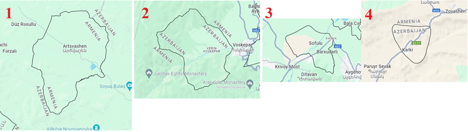
Map 7: visual comparison of the size of enclaves on an equivalent scale
1 – Artsvashen
2 – Yukhari Askipara (Verin Voskepar)
3 – Sofulu-Barkhudarly
4 – Kyarki (Tigranashen)
Moreover, by the beginning of the conflict, Artsvashen boasted a population (around 2,771 residents as of 1979) double that of all Azerbaijani enclaves combined. According to the 2009 Azerbaijani census, which continues to count the residents of these villages and their family members in their new places of residence, the total population of all enclave villages amounted to 1,620 people. Hence, at the start of the conflict, Azerbaijani sources estimated the population of the largest Azerbaijani enclave village of Yukhari Askipara at 500 people, while the 2009 census of migrants from this village indicated a figure of 637 individuals.
Meanwhile, a number of Russian-language publications cite a figure of 2,200 inhabitants for the enclave comprising the small villages of Sofulu and Barkhudarly, while the census of displaced persons in 2009 documented 182 and 421 people, respectively.
Furthermore, within the territory of the Armenian SSR, there were two small Azerbaijani enclaves (covering less than 0.2 km²) near the village of Yaradullu, Ghazakh district, which came under the control of Azerbaijan in 1992, along with the lands of the village of Paravakar, totaling an area of 800 hectares (about 8 km²).
The role of controlled border territories and practical suggestions for delimitation
If the Armenian discourse is centered around the non-existence of enclaves in the 1920s, and the absence of a legal foundation for their existence (although it remains unclear how, in this case, areas of the border with enclaves differ from others, and what precisely is depicted on all maps), then their Azerbaijani opponents focus on the strategic significance of their enclaves in contrast to the Armenian exclave of Artsvashen. These narratives are further fueled by intense internal political debate in Armenia and widespread conspiracy theories suggesting that the ceding of the enclaves and villages of Tavush will lead to a national catastrophe.
In particular, an important highway for Armenia’s connection to Iran (4.5 km) runs through the territory of Kyarki enclave, while the highway to Georgia runs through segments of the territory of “mainland” Azerbaijan in the vicinity of Kheyrimli-Voskepar villages. However, the most convenient and sole asphalt road from the Akhinjachay subdistrict of Gedabek district of Azerbaijan towards the district center of Gedabek, in turn, runs through Artsvashen. We are referring to approximately 20 Azerbaijani villages (Zamanly, Dyuz-Rasullu, Chay-Rasullu, Arabachi, Isaly, Mutudere, Kasymagaly, Farzaly, Shynykh, etc.) with a population of around 10 thousand people (8,200 as of 2009). Until August 1992, they were effectively in a semi-blockade, a crucial factor that prompted the mobilization and active engagement of the residents of these villages in the battles aimed at capturing Artsvashen. Given the large size of the Armenian exclave, bypassing it will cause more trouble for the Azerbaijani villagers compared to bypassing the Azerbaijani enclave of Kyarki, the only one serving as a passage for the interstate highway. It is also noteworthy that the North-South highway project is designed to bypass Kyarki.
Putting aside the scenarios regarding “blocking Armenia’s external communications with enclaves,” it becomes evident that regardless of the slow pace of new roads’ construction, to unblock these areas the Armenian side will have to build around 10 kilometers of bypass routes across different sections, a task that is likely not insurmountable. Conversely, reverting to borders with enclaves will create a number of other problems for the residents of these enclaves themselves and the neighboring Armenian population, entailing a significant increase in the costs of border protection for both sides. This inconvenience is especially relevant for villages surrounding Artsvashen and partly Yukhari Askipara.
In the Armenian-Azerbaijani discussions on the problems of enclaves and in the exploration of exchange options, the prevailing logic remains that of a zero-sum game, wherein one side’s gain entails an equivalent loss for the other. The idea that by regaining control over the enclaves it is possible to “close” the other side’s transportation links with the outside world, or transforming the enclaves into “armed bridgeheads” are based on the presumption that even after the resolution of border issues, the ongoing confrontation will inevitably continue. Consequently, delimitation itself turns from an element of conflict resolution into a way of intensifying it, as it seeks to neutralize strategic advantages and weaken the positions of the opposing side.
As highlighted earlier, gaining control over both Azerbaijani enclaves along with border villages of Ghazakh district, and Artsvashen along with a number of other key areas of the Armenian territory in the 1990s was primarily driven by the aspiration to maintain or establish dominance over essential communication pathways and to eliminate heavily penetrated sections of the territory of the opposing side for security considerations. Today, the challenge of communications stands as one of the most important and painful issues in the process of delimitation of the Armenian-Azerbaijani border. The formulation of optimal approaches also determines whether these negotiations will facilitate mutual understanding or deepen confrontation in relations between Yerevan and Baku.
The OSCE recommendations to delimitation commissions include a requirement to retain communication routes for the respective parties that rely on them:
“The Commission should discuss a possibility and principles for applying optimization procedure to the state boundary. When a material consent on optimization is reached, the following fundamental issues arise. Cases when optimization should be applied:
– creating the conditions for the residents of borderline territories, favorable for their traditional economic activities;
– maintaining smooth functioning of the existing road network to ensure transport communication between settlements and other economic entities;
– maintaining functioning of transboundary and national facilities of engineering, energy, transport, amelioration and municipal infrastructure, reserves, national parks;
– preserving objects of public worship;
– shifting boundaries towards natural terrain lines, which reduces the cost of framing the boundary and optimizes its surveillance.”
Based on these recommendations, efforts can be made to address the existing problems in the Armenian-Azerbaijani border area. For instance, in Armenia’s Tavush zone, the interstate highway M-16 “Krivoy Most” – Noyemberyan – border with Georgia intersects the former administrative border of Azerbaijan in three segments in the Voskepar area, extending into the neighboring country for a total length of 2.2 km. Reverting to the previous border would necessitate the Armenian side to construct bypass sections through more forested and mountainous terrain. Added to that, about 2.4 km of the highway linking Ijevan and the village of Vazashen passes through the territory of Sofulu-Barkhudarly enclave.
A 4.5 km long segment of the M-2 interstate highway (Yerevan-Iranian border) passes through the territory of Kyarki (Tigranashen) enclave. At the same time, contrary to common statements, this is not the only route linking Armenia to Iran. Another route, the M-10 highway, runs along the western shore of Lake Sevan, crossing the Selim Pass before connecting to the M-2 highway in Vayots Dzor. It is also possible to bypass Kyarki enclave along the Vedi-Lanjar highway (old highway).
Similarly, communication routes pass through the Armenian territory, linking separate areas of Azerbaijan’s territory with each other. Thus, a stretch of 3.2 km of highway connecting the Azerbaijani villages of Kushchu-Ayrum and Mazam (Mazamly) to the district center of Gazakh runs through the level terrain of Armenia to the north of the Joghaz Reservoir. Reverting to the old administrative border would compel Azerbaijani villagers to make a long detour, involving an ascent to the Odundagh Mountain along a winding road. Consequently, residents of the village of Mazam, instead of the usual 3.13 km through the “Berkaber ledge,” will have to go around it, by ascending the Odundagh Mountain massif and driving 11.4 km instead of 3.13 km. The expenses will be especially significant in winter, considering that the current flat route through the Azerbaijani-controlled territory of Armenia completely eliminates the need for winter tire changes, due to the inconsistent snow cover in the Joghaz valley. Moreover, upon Armenia’s ceding of the “mainland villages” of the same area – Ashagi Askipara and Baghanis-Ayrum, residents returning to these areas will encounter similar challenges, which in general will significantly complicate the life of villagers, who have also settled in new lowland villages in recent years. During Soviet years, they all used the route passing through Armenian territory. If the enclaves were to be returned, the procedure for entering the village would be even more difficult for residents of Yukhari Askipara. They would have to cross the Armenian border, travel 3.2 km through its territory, then enter Azerbaijan, and once again cross the Armenian border, then cross the border again before entering the enclave. Alternatively, for the initial bypass of Armenia, they would have to ascend the winding road to Odundagh and follow the old route.
Approximately 2.2 km of the highway linking the village of Bala Jafarli to the rest of Azerbaijan also runs through the territory of Armenia or along its border. Additionally, more than 6.5 km of the highway connecting about 20 villages of Akhinjachay subdistrict of Gedabek district in Azerbaijan with the district center passes through the territory of the Armenian exclave of Artsvashen. Aside from these villages, the road and land of Artsvashen are also used by residents of neighboring villages of Tovuz district. Thus, communications important for both sides cross the old administrative border between the Soviet republics of Armenia and Azerbaijan or pass through the territory of enclaves: a restoration of these borders will create for the residents of the border zone and overall for the connection of these nations with the outside world (in the case of Armenia, through interstate routes to Georgia and Iran) permanent or temporary obstacles.
It is for this reason that the approach of exchanging territories when delimiting the Armenian-Azerbaijani border is key. The principles of exchange, as well as the assessment of the amount of compensation for lost property during its implementation, should be a subject of separate discussions.
Here, first of all it is about documenting the actual exchange of enclaves, a measure that at one time significantly simplified the situation in the border zone for both the residents of Armenian and Azerbaijani villages. At the same time, the remaining difference in area between the overall size of Azerbaijani enclaves (44 km²) and 38.1 km² of Artsvashen could be compensated by territories important for Azerbaijani communications near the village of Bala Jafarli and part of the Paravakar-Yaradullu ledge.
The widespread belief about the greater value of Azerbaijani enclaves can be easily refuted by the fact that reverting to “enclave geography” scenario, instead of a single agreed-upon procedure for large area Artsvashen, the Azerbaijani side will have to resolve the issue of access to five smaller enclaves at once with all the deriving consequences (the necessity for negotiating the terms of access on a case-by-case basis, military presence restrictions typical for enclaves, setting up diverse communications and repair protocols in case of accidents on the territory of the neighboring state, etc.). With mutual consent, of course, such projects and proposals could be submitted for international or expert arbitration. Additionally, the experience of other nations could be studied.
It should again be emphasized that the creation of enclaves, a complex and “interdependent composition” of the borders of the republics was an element of Soviet policy aimed at preventing the “easy secession” of the union’s republics by creating conflict-prone points. A similar strategy can be observed in the formation of borders or autonomy models in the North Caucasus. Furthermore, apart from Armenia and Azerbaijan, a very similar pattern of “enclave formation” lacking clear and consistent logic was characteristic of Central Asia, where this issue is currently the most acute in relations between Uzbekistan, Kyrgyzstan and Tajikistan, leading to periodic local armed clashes. In wider international context, this phenomenon was also mirrored in relations between India and Bangladesh, until the countries exchanged 162 enclaves in 2016 (111 Indian and 51 Bangladeshi). Similarly, in 1996, Lithuania ceded its exclave of Pagiriai (since 1996 – Pogiri) to Belarus, receiving in return an equivalent piece of territory.
It is important that the problem of territory exchange extends beyond just enclaves and encompasses areas along communication lines, where agreements enable each of the parties to efficiently use their respective infrastructure. For Armenia, this primarily involves a section of the M-16 highway from Acharkut village to Voskepar, as well as a section of the Goris-Kapan highway, closed by Azerbaijan in 2021. For Azerbaijan, it includes a section of the road passing through Armenian territory, north of the Joghaz Reservoir between Kohnaqislaq and Yaradullu villages and around Bala Jafarli village. Proposals for exchanges in these zones include a reciprocal transfer of territories in the Joghaz Reservoir area (see Map 8). This entails a segment of Azerbaijani territory south of the Voskepar River passing to Armenia (controlled by it since the spring of 1992), while a similar area of Armenian territory north of the reservoir would pass to Azerbaijan (also under its control since early 1990s). Such an arrangement would allow the parties to preserve their existing communication routes; in addition, the border along the river and reservoir would be easier to protect, equip, and it is also intuitively clear to the residents of the border zone. For the Azerbaijani side, this also presents an opportunity to access the waters of the large Joghaz Reservoir, since reverting to the old borders would render it an internal reservoir of Armenia.
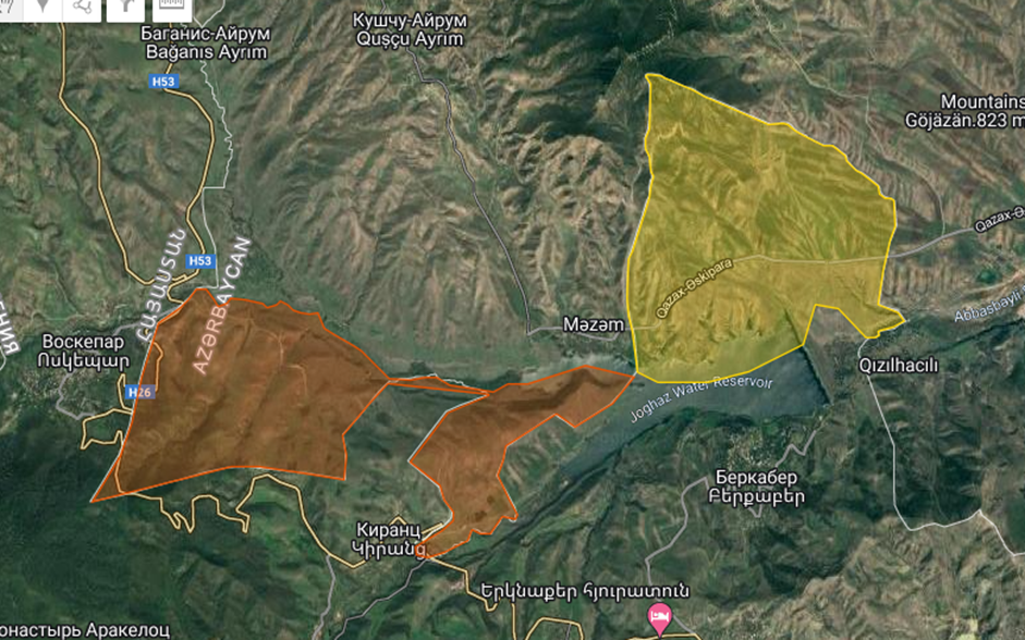
Map 8: the proposed exchange of territories in Joghaz Reservoir area
Discussions revolve also around the areas of the villages of Alibeyli and Aghdam of Tovuz district, closely adjacent to the former administrative border of Armenian SSR, where exchange could be a productive measure to preserve the lands and houses of villagers without dividing them by a border. Similar principles could also be applied in the Syunik zone, where the territory exhibits significant protrusions. Another important aspect is ensuring the protection and facilitating easier access to places of worship, especially in the border zone, which, however, is one of the most pressing issues given the “Albanian narrative”. For example, Surb Sargis Monastery in Ghazakh district, situated 1.3 km from the border with Armenia, used to be an important center of pilgrimage for Armenians across the region. By a similar logic, easier access to the graves and burial sites of loved ones is important in a long-term reconciliation policy. The consideration of the interests of each side and optimization of boundaries in accordance with this principle can significantly reduce tension and the likelihood of escalation in the border zone, create an atmosphere of trust among residents on both sides and lead to a gradual normalization of interstate relations as well. Such an approach – addressing current issues by minimizing their potential for conflict – is the only appropriate way to tackle more complex problems, since with increasing mutual trust, further concessions become less painful to perceive.
There are also reasonable grounds to believe that reducing the degree of hostility and peacefully resolving border and communications issues create preconditions for regional economic integration between the South Caucasian countries. All this will lead to easier transport procedures and create prospects for facilitated trade and transit regimes through each other’s territory. Consequently, there will be a resolution of the issues that the parties are currently trying to tackle by force, threats, or by obstructing the implementation of each other’s development initiatives. Meanwhile, the policy of forceful blackmail, the desire to maximize one’s own gains by ignoring the interests of the other side, as observed in relations between Baku and Yerevan over recent decades, lead to increased antagonism, revanchism and transformation of the Armenian-Azerbaijani conflict akin to the trajectory of the Arab-Israeli conflict.